
Do Flat Earth Maps Reveal a Hidden Truth?
Flat earth maps. Just two words, yet they send scientists into fits of laughter and believers into passionate lectures. But what if—just what if—they’re onto something? After all, if the Earth is really spinning at 1,000 miles per hour while orbiting the Sun at 67,000 mph, shouldn’t we feel at least a breeze?
Flat earth maps don’t just rearrange geography—they challenge everything you thought you knew about our planet. They ditch the spinning space marble in favour of a calm, flat disc. In these maps, the North Pole sits gracefully at the centre, and Antarctica becomes a mighty ice wall guarding the edge. Sounds like something out of a sci-fi novel—or maybe just the ultimate truth they don’t want you to know.
Why the Official Model Might Be Due a Rethink
Let’s be honest. Have you ever really seen the curve of the Earth? Not on a screen, not in a NASA press release, but with your own two eyes? Most of us haven’t. Yet we’re expected to believe the Earth is a ball because someone in a lab coat said so.
Here’s where flat earth maps come in. They suggest something different—something simpler. No southern hemisphere oddities, no disappearing planes over curved horizons, and certainly no photoshopped blue marbles from space. Just land, water, sky, and a map that finally makes sense when you lay it flat on the table.
Flat Earth Maps and Their Unmistakable Logic
Flat earth maps aren’t just artistic guesses. They’re meticulously designed, using the Azimuthal Equidistant Projection, where all continents are spread evenly around the North Pole. Conveniently, this is also the same layout used by the United Nations flag. Coincidence? Maybe. Or maybe it’s hiding in plain sight.
In this model, the sun and moon circle overhead like celestial drones, lighting up different parts of the world in shifts. Time zones? Sorted. Sunrises? Explained. Midnight sun in Antarctica? Well, we’re still figuring that bit out—but don’t worry, so is science.
Navigating a Flat World: Surprisingly Practical
Now, you might be thinking, “But how do planes work on flat earth maps?” Funny you should ask. Some flight paths make more sense when viewed on these maps. For example, ever wondered why there are no direct flights between certain cities in the Southern Hemisphere? The answer’s obvious—if you’re looking at the right map.
GPS? Sure, it claims to rely on satellites, but there’s little proof they’re floating in space rather than attached to high-altitude balloons. Look up “satellite balloons” sometime—if Google hasn’t scrubbed it clean yet.
Trusting NASA or Trusting Your Eyes?
NASA says Earth is round. But NASA also says we went to the moon with 1960s tech and now somehow can’t get back. Hmm. Their photos of Earth show a perfectly round sphere, always conveniently centred. Ever noticed how the continents seem to change size every few years? Perspective, they say. Or Photoshop, maybe? Apollo 11 Facts They Don’t Teach You in School
Meanwhile, flat earth maps show a consistent layout. Continents don’t shrink or stretch. Everything’s there, flat as your kitchen table, just waiting to be explored—no curvature required.
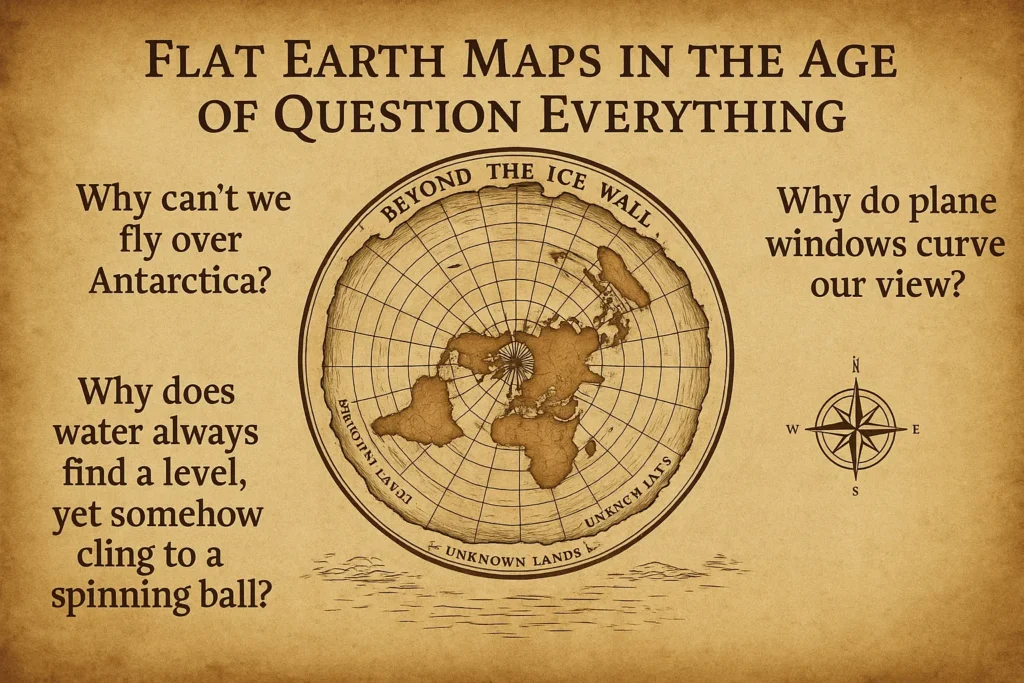
Flat Earth Maps in the Age of Question Everything
It’s not about denying science—it’s about asking questions science doesn’t like.
- Why can’t we fly over Antarctica?
- Why do plane windows curve our view?
- Why does water always find a level, yet somehow cling to a spinning ball?
Flat earth maps don’t claim to have all the answers, but they do raise some very awkward questions. That alone is reason enough to keep them on the table, next to your compass and a well-worn copy of “1984”.
Final Thoughts: Are Flat Earth Maps a Joke—Or Just Ahead of Their Time?
Maybe flat earth maps are wrong. Maybe the Earth really is a giant spinning sphere hurtling through space. But maybe—just maybe—there’s more to the story than we’re being told. After all, questioning accepted wisdom is how progress happens. And if that means giving flat earth maps a second look, why not? Worst case, you’ll end up with a very cool conversation starter.
FAQs
1. What are flat earth maps actually based on?
Mostly on the Azimuthal Equidistant Projection, which, oddly enough, is also used by the UN.
2. Do these maps make more sense than globes?
In some ways, yes—especially if you like your water to stay level and your continents not to wobble.
3. Why is there an ice wall around the edge?
That’s Antarctica, of course. It’s not just a continent—it’s the barrier keeping everything in.
4. Why aren’t we taught this in school?
Well, schools also taught us Pluto was a planet. So… make of that what you will.
5. Should I ditch my globe for one of these?
Maybe not just yet. But it wouldn’t hurt to keep one around—you know, just in case.


